Log in
All resources
Create a design
9,296 Free Artworks of Map Collection
bibliothèque nationale de france
chorographia britanniae (1741-1742)
national library of poland
eran laor cartographic collection
paper
british museum
de praecipvis totivs vniversi vrbibvs, liber secvndvs (1575)
maps by thomas kitchin
thomas kitchin
maps by willem and johannes blaeu
vrbivm praecipvarvm mvndi theatrvm qvintvm (1617)
maps of visegrád by braun & hogenberg
vrbivm praecipvarvm mvndi theatrvm qvintvm (1617)
maps of heide by braun & hogenberg
fonds ancely - bibliothèque municipale de toulouse - maps
19th-century maps of calvados
maria theresa of austria by martin van meytens
maria theresa in hungarian coronation robes
napoleon on saint helena
emmanuel de las cases
maps of paradise by mercator-hondius
eran laor cartographic collection
maps of south america by mercator-hondius
eran laor cartographic collection
eran laor cartographic collection
maps of china by mercator-hondius
map of italy by guillaume delisle (1700)
1700 maps of italy
henri le roy (1579-)
diocese of aire
juan francisco leonardo (1687) mapa del arzobispado de toledo
1680s maps of spain
18th-century maps of kent
maps by thomas kitchin
old maps of northumberland
maps by thomas kitchin
an accurate map of england and wales , drawn from all the particular surveys hitherto publish'd. illustrated with many additional improvements, and regulated by numerous astronomical observations made by... - btv1b53181614s
maps by thomas kitchin
an accurate map of england and wales , drawn from all the particular surveys hitherto publish'd. illustrated with many additional improvements, and regulated by numerous astronomical observations made by... - btv1b53181614s
maps by thomas kitchin
atlas maior, vol 1 (northern europe, norway, and denmark) - joan blaeu, 1667 - bl 114.h(star).1
1667 maps
atlas maior, vol 1 (northern europe, norway, and denmark) - joan blaeu, 1667 - bl 114.h(star).1
1667 maps
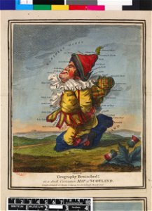
satirical prints in the british museum
works after robert dighton
drawings in the metropolitan museum of art
johannes brandenberg
maps of the course of the rhine by guillaume sanson
bibliothèque nationale de france
map of the circle of swabia by sanson
bibliothèque nationale de france
1667 map of madagascar by guillaume sanson
bibliothèque nationale de france
bibliothèque nationale de france
sanson maps of asia
department of american paintings and sculpture, metropolitan museum of art
drawings by daniel huntington
1670s maps of rhineland-palatinate
maps of vangiones by sanson
17th-century maps of the indian ocean
maps by willem and johannes blaeu
maps by pieter mortier
maps from gallica
bibliothèque nationale de france
maps by tomas lopez
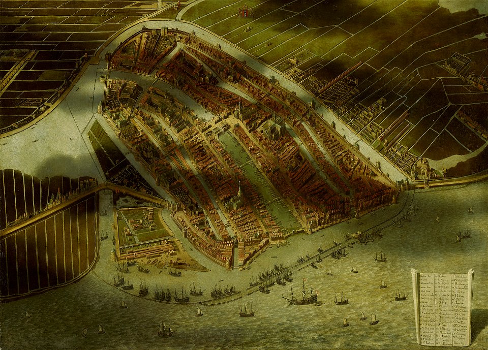
topographical paintings in the amsterdam museum
paintings of amsterdam
eran laor cartographic collection
pierre mortier
eran laor cartographic collection
alexis-hubert jaillot
eran laor cartographic collection
antonio lafreri
eran laor cartographic collection
philippe de la rué
maps and topographical views by joris hoefnagel
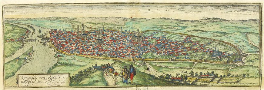
maps of rouen by braun & hogenberg
1667 sanson map of africa
1726 maps of africa
maps of genoa by braun & hogenberg
baroque
maps by hendrik hondius the younger
old maps of gâtinais and sénonais
maps of cagliari by braun & hogenberg
bibliothèque nationale de france
maps of the magellan straits by lambert cornelis
bibliothèque nationale de france
maps by nicolas sanson
sanson maps of asia
portrait paintings of james francis edward stuart
antonio david
1792 in berlin-mitte
1792 maps of berlin
atlas vingboons
1665
maps by claude joseph sauthier
old maps of new york (state)
chorographia britanniae (1741-1742)
18th-century maps of hampshire
chorographia britanniae (1741-1742)
18th-century maps of rutland
geographia universalis (1545) in the british museum
german renaissance,northern renaissance
chorographia britanniae (1741-1742)
18th-century maps of suffolk
maps and topographical views by joris hoefnagel
1580s maps of spain
chorographia britanniae (1741-1742)
18th-century maps of yorkshire
de praecipvis totivs vniversi vrbibvs, liber secvndvs (1575)
maps of vejer by braun & hogenberg
old maps of the rhineland
maps by gerard de jode
chorographia britanniae (1741-1742)
18th-century maps of staffordshire
18th-century maps of england and wales
chorographia britanniae (1741-1742)
chorographia britanniae (1741-1742)
18th-century maps of lincolnshire
17th-century maps of carmarthenshire
17th-century maps of pembrokeshire
17th-century maps of the strait of magellan
maps by willem and johannes blaeu
18th-century maps of norfolk, england
chorographia britanniae (1741-1742)
chorographia britanniae (1741-1742)
1740s maps of wales
18th-century maps of herefordshire
old county maps of herefordshire
de praecipvis totivs vniversi vrbibvs, liber secvndvs (1575)
maps of konstanz by braun & hogenberg
maps of rodrigues island
old maps of mauritius
chorographia britanniae (1741-1742)
18th-century maps of dorset
maps in the british museum
german renaissance
geographia universalis (1545) in the british museum
german renaissance,northern renaissance
chorographia britanniae (1741-1742)
18th-century maps of hertfordshire
chorographia britanniae (1741-1742)
18th-century maps of warwickshire
de praecipvis totivs vniversi vrbibvs, liber secvndvs (1575)
maps of conil by braun & hogenberg
chorographia britanniae (1741-1742)
18th-century maps of worcestershire
chorographia britanniae (1741-1742)
old county maps of county durham
18th-century maps of northamptonshire
chorographia britanniae (1741-1742)
18th-century maps of gloucestershire
chorographia britanniae (1741-1742)
chorographia britanniae (1741-1742)
18th-century maps of cheshire
18th-century maps of buckinghamshire
chorographia britanniae (1741-1742)
de praecipvis totivs vniversi vrbibvs, liber secvndvs (1575)
maps of oxford by braun & hogenberg
chorographia britanniae (1741-1742)
18th-century maps of berkshire
chorographia britanniae (1741-1742)
18th-century maps of somerset
de praecipvis totivs vniversi vrbibvs, liber secvndvs (1575)
maps of corfu by braun & hogenberg
old maps of whole wales (alone)
1670s maps of wales
chorographia britanniae (1741-1742)
18th-century maps of surrey
chorographia britanniae (1741-1742)
18th-century maps of shropshire
chorographia britanniae (1741-1742)
18th-century maps of leicestershire
chorographia britanniae (1741-1742)
18th-century maps of bedfordshire
maps in the british museum
german renaissance
chorographia britanniae (1741-1742)
18th-century maps of devon
chorographia britanniae (1741-1742)
1740s maps of wales
chorographia britanniae (1741-1742)
18th-century maps of derbyshire
maps in the british museum
german renaissance
william dugdale
baroque
maps of the west-indische compagnie
1665
maps from university of amsterdam special collections
atlas der neederlanden
portrait paintings by john trumbull
romanticism
drawings by johan frederik clemens in the statens museum for kunst
brown ink
drawings (documentary) collection in the library of congress
drawings by alfred waud
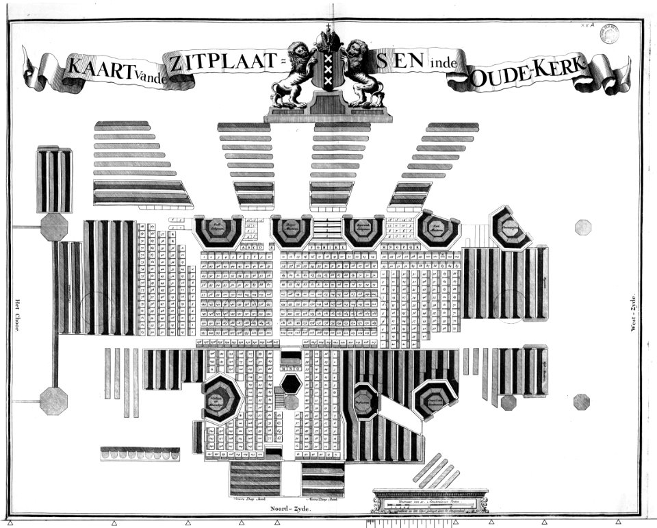
construction drawings in the stadsarchief amsterdam
daniel stoopendaal
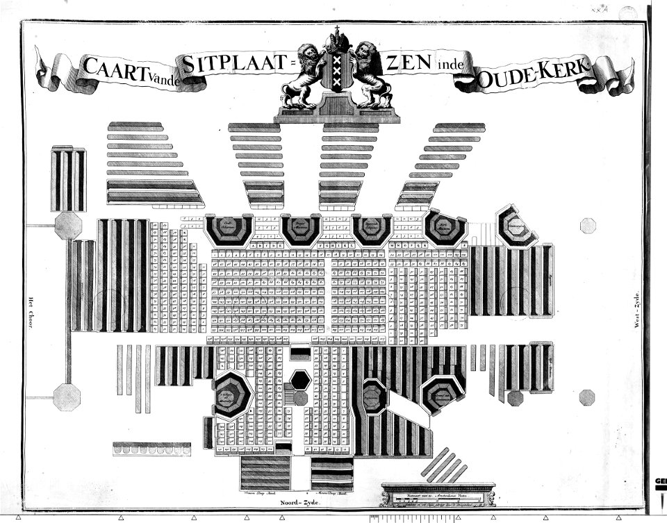
construction drawings in the stadsarchief amsterdam
daniel stoopendaal
collections of archives départementales de la marne
postcards of marne
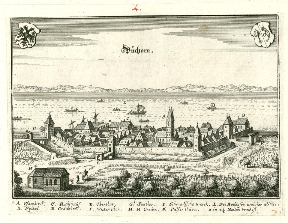
antoine-françois tardieu
1800s maps of hispaniola
antoine-françois tardieu
1800s maps of hispaniola
moll's map collection
baroque
4701 - 4800 of 9,296
Next page
/ 93